
Septic Tank Installation: A Complete Step-by-Step Guide
Whether you’re building on a rural lot or replacing a failing system, septic tank installation is one of the most regulated, and most consequential projects a homeowner can take on.


In many cases, you’ll receive your plan as a subdivision site plan PDF or even as a downloadable template. Regardless of the format, knowing how to interpret it will help you make informed decisions about construction, landscaping, and compliance with local regulations.
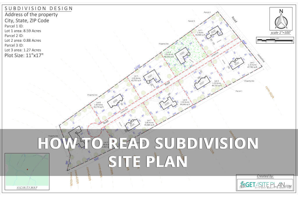
At first, subdivision site plans may look like a confusing mix of lines, numbers, and symbols – but once you know what to focus on, it becomes a valuable tool for understanding your property.
In this guide, we’ll walk you through each section of a typical plan, explain how to interpret technical symbols, and show you how to avoid costly mistakes.
Before we dive into the steps, remember this: a site plan is a map. It tells a visual story about how a subdivision is laid out – where roads provide access, where infrastructure runs, and how each lot is designated.
Since it’s a map, it usually has universal technical symbols that occur in almost every subdivision site plan:
Here’s where to begin and how to interpret each element of the subdivision site plan.


Title block element is usually found at the bottom or corner of the plan. It typically includes plan name, subdivision name, parcel number (APN), date, and scale.
Represented as a compass arrow icon, the north arrow is usually placed in the top right corner of a subdivision site plan. North arrow shows orientation (important for setbacks and landscaping).
This element helps you understand sun exposure, landscaping considerations, and placement of structures.
Besides the north arrow, there’s usually a scale at the same place which tells you how distances on the plan translate to real-world measurements. For example, 1’’=100’ means every inch on the plan equals 100 feet on the ground.

The outermost thick solid line represents the boundary of the entire subdivision. Inside, you’ll see thinner lines dividing individual lots.
Key distinctions:

Setbacks and easements are two of the most critical elements on any site plan because they dictate how you can use your land.

Your plan will also show what’s currently built or present on the land.
Common features on subdivision site plan:
This step is essential when planning additions or landscaping changes.
Some site plans also include future updates or proposed developments.
These are often shown in:
For example, a proposed garage or patio might be indicated with a lighter dotted outline next to the existing home. However, keep in mind that proposed changes may require HOA or city approval before construction begins.
If you’re planning updates or modifications to your property, you can have a revised subdivision site plan design created online to visualize your proposed changes with GetASitePlan.
Our service can quickly prepare updated drawings that include both existing and proposed structures, making it easier to review before submitting to your local planning department.

The legend is your decoding tool. It explains what each symbol, line type, or abbreviation means.
Key information found in the legend:
This section ensures you can accurately interpret technical information without guesswork.
(If you don’t already have one, our guide on How to Obtain a Subdivision Site Plan explains the process step-by-step, from requesting documents to reviewing final designs.)
Here’s a table summarizing how the symbols and elements are represented in the subdivision site plan.
| Symbol/Label | What It Means |
| Solid line | Property boundary |
| Dashed line | Easement or setback |
| Triangle marker | Utility location |
| Circle with X | Tree to be removed/relocated |
| N or arrow symbol | North direction |
Table 1: Meaning of subdivision site plan symbols/labels

Most subdivision site plans today are shared digitally, either as templates or PDFs. Understanding how to read a subdivision site plan template or how to read a subdivision site plan PDF will help you correctly interpret your property’s layout, zoning information, and legal boundaries.
Both formats contain the same essential data, including boundary lines, setback distances, zoning classifications, lot dimensions, drainage patterns, and legend keys. However, the way you interact with each format is slightly different.

Subdivision site plan templates are usually editable files designed for early planning or proposed changes. Developers, surveyors, or homeowners may use them to map out new ideas before finalizing the official version.
Key benefits of templates:
When reading a subdivision site plan template:
Templates are ideal for planning and early-stage development, but they must eventually be reviewed by a licensed surveyor for accuracy and legal approval.

PDFs are the most common format for finalized subdivision site plans because they preserve precise scale ratios and cannot be altered. This makes them reliable for official submissions to municipalities or HOAs.
Why PDFs subdivision site plans are preferred:
When reading a PDF subdivision site plan:
Whether you are reading a template or a PDF, the process of interpretation remains similar:
(PDFs are excellent for showing exact lot dimensions and property boundaries as well – see How to Read a Plot Plan showing these elements)
Whether you’re working with a PDF or an editable template, there are practical strategies that can make understanding a subdivision site plan much simpler and less overwhelming.

Reading a subdivision plan can feel overwhelming, but with a systematic approach, it becomes manageable.
Here are practical tips to make the process smoother:
Take notes as you go:
By following these tips, you’ll better understand the scaled, visual, and legal aspects of your subdivision site plan, and avoid some potential mistakes when reading it.

Even with the right information, homeowners often make errors when trying to interpret or analyze a subdivision site plan.
Avoid these common mistakes when reading a subdivision site plan:
Lastly, remember that the surveyor draws the site plan to be technically accurate, but it’s up to the property owner to understand and follow it correctly.

A subdivision site plan isn’t just a formality – it’s a vital document for protecting your investment and ensuring compliance with local laws.
In short, a site plan is the blueprint for responsible, safe, and efficient property development.
Yes. While surveyors and engineers receive technical training, homeowners can learn to read a site plan by following step-by-step instructions and referencing the legend for guidance.
No special software is required. Most PDF viewers allow you to zoom, pan, and print the document. However, specialized design software may be helpful if you need to make edits to a template.
If something appears incomplete or hard to interpret you can contact the surveyor or developer who created the plan, verify measurements with your local zoning office, or avoid starting any construction until discrepancies are resolved.

Reading a subdivision site plan is more than just understanding a map – it’s about gaining a clear vision for how a property is designed, organized, and regulated. By carefully reviewing lot boundaries, setback distances, easements, and zoning classifications, you can make informed decisions that prevent costly mistakes and delays.
Once you feel confident interpreting your plan, consider getting a custom subdivision site plan from GetASitePlan. Our team provides accurate, permit-ready subdivision site plans tailored for permits, HOAs, or early project design – delivered within 24 hours.

Whether you’re building on a rural lot or replacing a failing system, septic tank installation is one of the most regulated, and most consequential projects a homeowner can take on.
Ever tried explaining your dream deck without a drawing? Suddenly everyone’s imagining a different patio. That’s where a deck plan saves the day – the visual roadmap that turns “I

A landscape rendering gives you a 3D preview of your garden or yard – a chance to see every angle before any work begins. And it has gone digital. What