
How Much Does a Site Plan Cost (and Plot Plan)?
The answer on how much the site plan cost depends on one key decision – whether you need a non-certified drafting plan or a certified, stamped document from a licensed


Picture standing over a blueprint that shows the future of your land – where roads will curve, how each lot will breathe, where every pipe, fence, and tree will fit.
That’s what a Subdivision site plan reveals – the DNA of your property’s potential.
Whether you’re a homeowner dividing land or a developer mapping new neighborhoods, understanding how these plans work is your first step toward approval, precision, and peace of mind.
In this guide, you’ll learn what a subdivision site plan includes, who prepares and approves it, see real examples and downloadable templates, and discover how to order one professionally for your project.

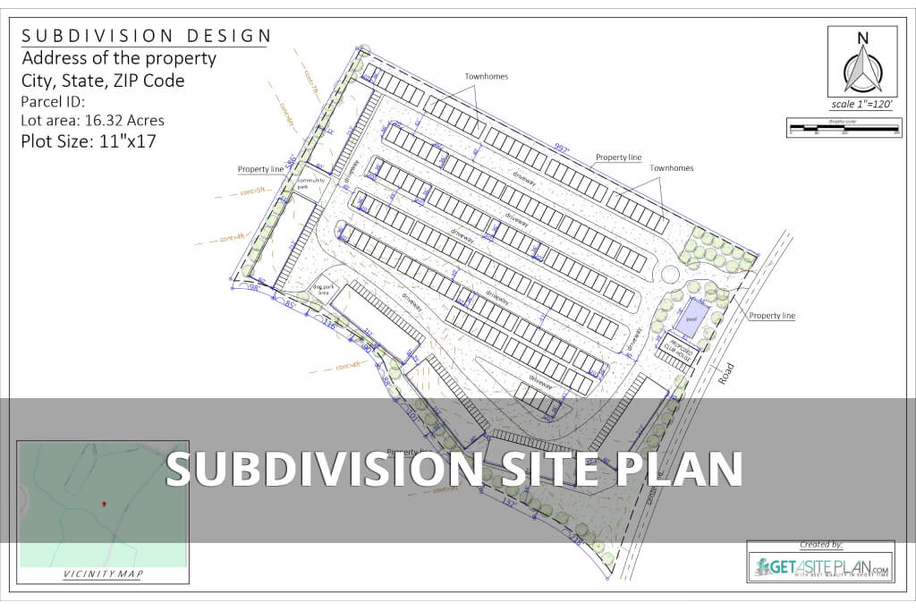
A subdivision site plan is a scaled engineering drawing that shows how a single parcel of land will be divided into smaller lots and supported by roads, drainage, and utilities. It’s prepared by a civil engineer or licensed surveyor and submitted by a developer for municipal approval.
Each plan outlines boundaries, setbacks, topography, and easements, ensuring the design meets zoning, infrastructure, and environmental regulations.
In short, it’s the link between an idea and legal permission. (To understand how this document fits into the larger process, see our guide on “Land Subdivision”).


Subdivision site plans exist to ensure every new neighborhood or property division follows safe, regulated design principles. They guide municipalities in verifying that each lot has access to public roads, utilities, and drainage systems, while meeting zoning codes and density limits.
For developers, a site plan coordinates construction, surveying, and infrastructure planning before a single line is marked on the ground. For cities, it’s a tool of regulation, confirming that roads connect, utilities align, and environmental impact is minimized.
Without an approved plan, projects risk legal delays, fines, or rejection during the permit stage. That’s why most municipalities require a subdivision site plan before issuing any development or building approvals.
Let’s break down what details are actually shown inside a typical subdivision site plan.

A detailed subdivision site plan acts as a visual checklist for planners and surveyors.
Being a visual checklist, a subdivision site plan typically includes:
Each element links design, safety, and functionality. Together, they create a regulated, livable environment – from efficient infrastructure to balanced land use.
Now that you know the components, let’s clarify how a subdivision site plan differs from other common planning documents.
It’s easy to confuse a subdivision site plan with similar terms.
Here’s how subdivision site plans differ from other planning documents:
The site plan bridges concept and approval, while the plat map finalizes the legal record. Each plays a unique role in the development process, and all three must align before permits are granted.

Preparing a subdivision site plan is a structured process involving both fieldwork and drafting.
Here are steps for creating a subdivision site plan:
This process ensures compliance, coordination, and long-term infrastructure reliability. Let’s see what real subdivision site plan examples and templates look like in practice.

A subdivision site plan example shows more than measurements – it shows how engineers turn land into connected, functional communities.
Residential examples often include lot numbering, driveways, drainage lines, and road access. Larger commercial subdivisions may display traffic routes, utility corridors, and grading elevations.
Templates or sample PDFs are great learning tools for understanding layout, zoning, and compliance visually. They demonstrate how every boundary interacts with infrastructure and regulation.

Creating a compliant site plan requires collaboration of a few different persons.
People involved into subdivision site plan creation and approve are:
In short – the developer submits, the engineer designs, and the municipality approves.
This process aligns private goals with public safety – balancing design creativity with municipal oversight. It also ensures that roads, easements, and utilities meet long-term community standards.
Each participant has defined responsibility: the engineer designs, the developer plans, the municipality inspects.
There are several ways to access or order a subdivision site plan:

For detailed instructions, see our “How to Read a Subdivision Site Plan”.
The typical cost of online subdivision site plans start around $89–$359, while certified surveyor plans typically range from $800–$2,500+, depending on complexity.
Yes, you can prepare a subdivision site plan yourself, sketch concepts, but only a licensed engineer or surveyor can produce official, approvable documents.
Subdivision site plan should be detailed as it must include lot dimensions, roads, drainage, zoning, and topography to satisfy municipal review.
The difference between a subdivision site plan and a site map is clear – a site map is illustrative;, while a subdivision site plan is engineered, scaled, and regulated.

A subdivision site plan is the foundation of every successful land development project.
It ensures compliance, guides construction, and protects long-term property value.
From zoning and setbacks to drainage and infrastructure, it’s the blueprint that keeps growth safe and organized.
Whether you’re preparing to subdivide land, plan a new community, or simply understand your property better, mastering this document is your first step toward confident, compliant development.
If you need a ready-to-use subdivision site plan for your project, GetASitePlan offers fast, GIS-based layouts designed to meet most municipal standards within 24 hours.

The answer on how much the site plan cost depends on one key decision – whether you need a non-certified drafting plan or a certified, stamped document from a licensed

Adding square footage is one of the most reliable ways to improve comfort, functionality, and long-term property value. Whether you’re considering a primary suite, a kitchen expansion, or building a

If you’re preparing a permit submission and wondering whether a Google Maps screenshot will do the job, you need a clear answer before you spend time, or money, on the