
Septic Tank Installation: A Complete Step-by-Step Guide
Whether you’re building on a rural lot or replacing a failing system, septic tank installation is one of the most regulated, and most consequential projects a homeowner can take on.


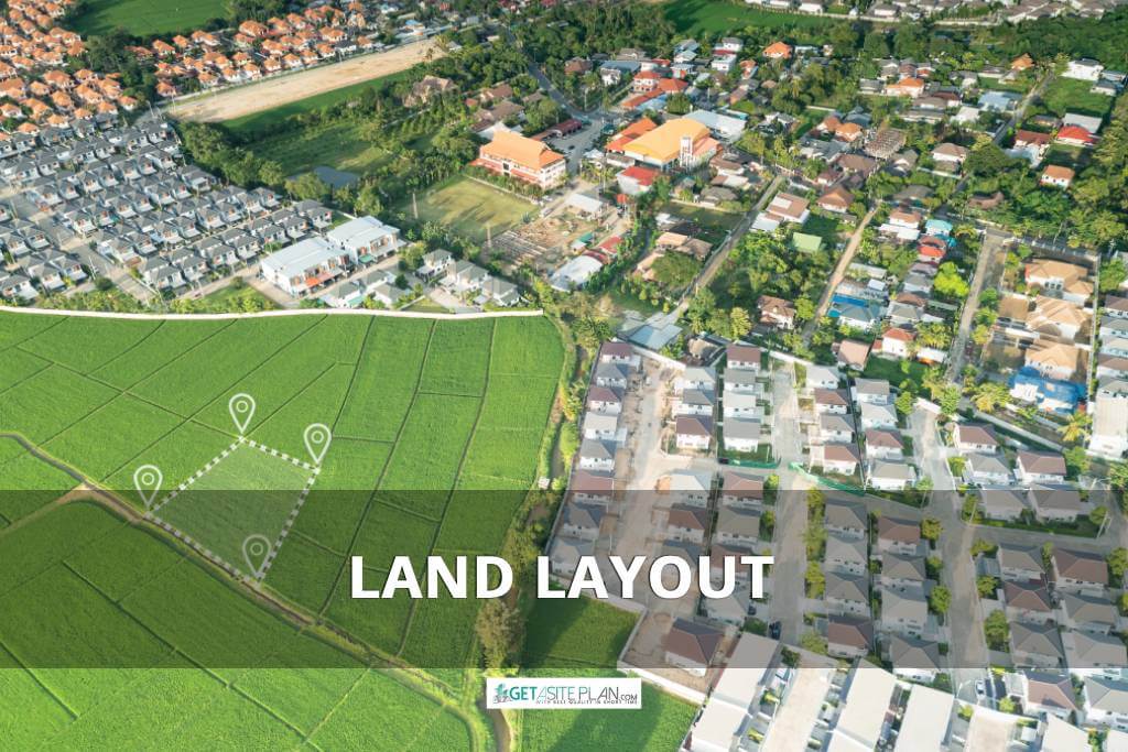

A land layout is a precise plan that maps out how a piece of land is divided, zoned, and designed for optimal use.
It aligns boundaries, measures plots, and considers topography to create well-planned and efficient spaces. Surveys, zoning, and strategic subdivision planning ensure every zone is utilized effectively.
Keep reading to uncover everything about land layouts, from meaning to design.
Utilizing the right tools or obtaining professional land layout plans makes the design process more efficient, ensuring a smooth transition from concept to construction.

A land layout refers to the strategic organization and design of land to maximize its usage.
It serves as a blueprint that defines how plots, roads, utilities, and open spaces are arranged within a specific area. This helps ensure the land is used efficiently, aligning with local zoning rules and regulations, environmental factors, and site developmental goals.
A well-crafted land layout offers:
According to FEMA guidelines, a well-designed land layout is essential for optimal land use, compliance with zoning regulations, and infrastructure efficiency [1].
Nevertheless, to better understand how land layouts are applied in real-world scenarios, let’s explore some of their common uses.

Land layouts play a crucial role across various fields and industries, ensuring strategic design and efficient land utilization.
They are commonly used in:
Here’s a table summarizing the land layout’s main characteristics.
| Aspects | Details |
| Definition | Strategic plan that organizes land into zones, plots, and infrastructure |
| Purpose | Efficient use of land, compliance with regulations, and clear boundaries |
| Applications | Urban planning, residential, commercial, industrial, agricultural, and recreational uses |
| Benefits | Improved clarity, efficiency, compliance, and overall land value |
Understanding these diverse applications of land layouts lays the foundation for exploring the types of layouts tailored to meet specific needs and uses.

Land layouts come in various forms, each designed to suit specific purposes and ensure the efficient use of space (sometimes beginning with a plot plan to define land boundaries and ensure proper zoning).
Here are some common types of land layouts:
Each type reflects the property’s purpose, ensuring clear boundary definitions, infrastructure is placed strategically, and land is used effectively.
Planners optimize land use by tailoring layouts to meet the needs of different spaces, surveyors measure boundaries, while designers create land layouts, and integrate zoning regulations and terrain-specific adjustments.
Now that we’ve explored the different types of land layouts, let’s dive into the design process, where precision, symmetry, and usability come together to prepare a landscaping integration.

Designing a land layout involves transforming a plot of land into a functional and aesthetic space that meets specific needs.
The process includes several stages, from land surveying and defining boundaries to zoning and infrastructure planning. Using the right tools and software can enhance precision and efficiency, ensuring a well-designed layout.
Land layout design is the process of creating a blueprint for how land will be used and structured.
It involves aligning boundaries, surveying the terrain, and mapping out zones to optimize functionality and efficiency. Whether for a flat site or a rugged landscape, layout design ensures feasibility and visual appeal.
Designers and planners consider factors such as zoning regulations, sustainable drainage systems, and infrastructure placement to create layouts that are adaptable and compliant with local requirements.
Yet, there’s an option to create a land layout yourself.
Designing and drawing a land layout involves a series of carefully planned steps to ensure the land’s functional use while maintaining its aesthetic appeal.
The process typically includes:
As an alternative, you can use GetASitePlan, an online drawing service, to get site plans and streamline the process, saving time and sparing unnecessary steps while defining space organization and infrastructure placement.

Yet, if you want to do it yourself, using a land layout planner or design software can help organize these tasks with precision and efficiency.

Various apps and software provide tools for measuring terrain, zoning areas, and creating blueprints.
Some commonly used software include AutoCAD, SketchUp, or Revit.
For a more comprehensive list of software options, including those specifically for drawing site plans, refer to our article on ‘Best Software for Drawing Site Plans.’
Lastly, once the design process is complete, obtaining or downloading a professional land layout plan from an online platform can help ensure the design is implemented accurately.
After designing your land layout, acquiring a professionally drawn plan can help bring your project to life.
Depending on your needs, there are various options for obtaining or downloading a land layout plan:
These options help simplify the process, ensuring you get a land layout plan that is both precise and compliant with your needs.
Title: Redesigning your land into a functional space
Caption: Converting your land into a structured and appealing layout
A well-designed land layout serves as the foundation for any successful project, whether residential, commercial, or agricultural.
A clear, precise plan also aids in managing resources, avoiding costly mistakes, and ensuring compliance with local rules and regulations.
Whether you’re developing a new property or redesigning an existing one, a carefully crafted land layout helps transform raw land into a valuable, productive space.
References:

Whether you’re building on a rural lot or replacing a failing system, septic tank installation is one of the most regulated, and most consequential projects a homeowner can take on.
Ever tried explaining your dream deck without a drawing? Suddenly everyone’s imagining a different patio. That’s where a deck plan saves the day – the visual roadmap that turns “I
A landscape rendering gives you a 3D preview of your garden or yard – a chance to see every angle before any work begins. And it has gone digital. What