
Septic Tank Installation: A Complete Step-by-Step Guide
Whether you’re building on a rural lot or replacing a failing system, septic tank installation is one of the most regulated, and most consequential projects a homeowner can take on.


A site plan provides a visual and detailed outline of proposed developments on a property, while a land survey establishes the land’s precise boundaries and technical measurements.
Yet, the terms site plan and land survey are often used interchangeably, creating confusion for those seeking accurate property documentation. However, these documents are not the same.
So, whether you’re ensuring accurate project planning or verifying property boundaries, understanding these differences helps you compare the two and choose the right document for your needs.
Here’s everything you need to know.

Site plans and surveys share similarities, often leading to them being grouped under the broad category of survey types.
However, their distinctions become clear when you compare their purpose, usage, level of detail, included elements, and legal status.
Let’s see those differences in detail.

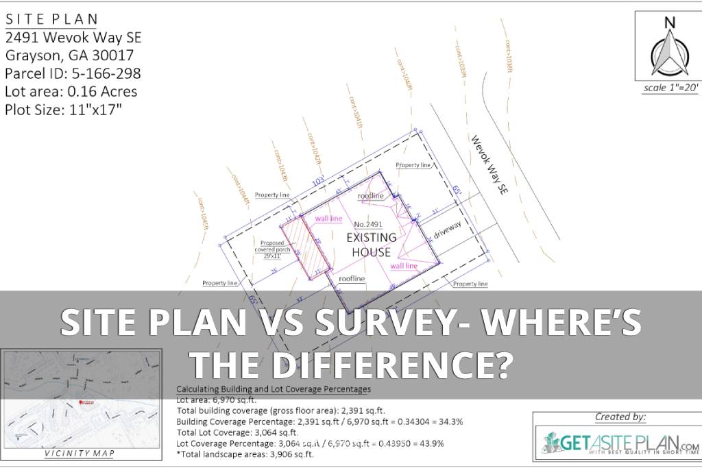
The primary purpose of a site plan is to visually illustrate property layout, focusing on how the property will be used or developed, often emphasizing proposed structures, landscaping, and utility connections.
It also highlights the regulatory compliance necessary for approval – zoning regulations affect site plans, which must align with local requirements (you can get a clearer picture of why they’re used for these purposes by reviewing site plan examples).
A land survey, on the other hand, is created to establish accurate legal boundaries and measurements, serving as a legal record of the land’s dimensions and features (it marks the property’s physical boundaries).
Site plans are commonly used for construction projects, permit applications, and planning developments.
Surveys, however, are essential when buying or selling property, resolving boundary disputes, or ensuring compliance with zoning regulations.

While site plans focus on visual and functional details relevant to a project, surveys provide technical and highly accurate measurements (the same reason people often confuse plot plans and land surveys).
A site plan typically includes detailed property layouts, emphasizing the development aspects of the property.
The elements included are:
This applies to commercial and residential site plans, each tailored to the project’s specific needs. If you’re new to site plans, understanding how to read site plan elements accurately can be essential for ensuring compliance with zoning regulations and development goals.
The key elements of a survey are:
Understanding how to read land surveys can help you interpret these elements, ensuring you clearly understand the land’s dimensions.
Surveys are often legally required for property transactions and are recognized as official documentation by local authorities.
Documentation verifies land dimensions and the survey establishes legal property lines, which are critical for legal proceedings.
On the other hand, site plans, while important for project approval, usually do not carry the same legal weight unless stamped by a licensed professional.
Here is the table summarizing all the differences.
| Aspect | Site Plan | Land Survey |
| Purpose | Visual outline of proposed developments | Establishes legal boundaries and measurements |
| Usage | Construction projects, permits, planning | Property transactions, legal disputes |
| Key Elements | Property layout, buildings, landscaping, utilities | Property lines, legal descriptions, easements |
| Legal Status | Not always legally binding unless certified | Legally recognized, required for transactions |
| Cost | Typically more affordable (e.g., DIY or online services) | Higher due to professional surveyor fees |
But are these differences the same when comparing any type of survey with a site plan?

There are multiple types of surveys, each serving a specific purpose.
Understanding the distinctions between site plans and these surveys can help you choose the right document for your project needs.
A topographic survey is often used for grading, drainage, or large-scale construction projects.
Measurements analyze topographical data, whereas a site plan details construction design and emphasizes proposed developments without detailed elevation data.
An ALTA (American Land Title Association) survey provides comprehensive property details and is primarily used for legal and financial transactions, such as property sales or loans.
A site plan, however, centers on visual representation for site plans to visualize property usage for planning and permitting purposes, often without the legal depth required for ALTA surveys.
A boundary survey is commonly used to resolve disputes or meet zoning requirements.
However, the site plan, which is critical for project planning and approval, also outlines proposed changes or developments, taking into account setbacks and elevations.
A property survey is a general term for surveys that detail a property’s boundaries, improvements, and features.
Unlike a property survey, a site plan goes beyond documenting what currently exists by outlining proposed changes or developments, making it a key document for project planning.
Also, the site plan provides a conceptual representation of how the property will be utilized, considering scalability and the property’s functionality.

While both site plans and surveys are essential documents, the expenses involved can vary significantly based on the type of professional service required and the complexity of the project.
However, in general, site plans are more cost-effective since they typically don’t require hiring a licensed professional, unlike land surveys, which mandate professional involvement.
Hiring a licensed land surveyor can be costly, with prices ranging from $500 to $1,500 or more, depending on the property size, location, and survey type. Since surveys are essential for resolving legal matters, expenses are often justified.
However, for projects that DO NOT require legal certification, such as site planning, hiring a surveyor might not be necessary.

Creating a site plan can be significantly more economical, especially if you choose an online drawing service like GetASitePlan where you can get one for less than $90.
With this service, you can, within 24 hours, obtain a professionally drafted and compliant site plan for permits without the high fees associated with traditional surveyors or design firms.
DIY solutions are also an option in some areas like Indianapolis, especially if you learn how to draw a site plan yourself [1].
However, when preparing your site plan, it’s essential to measure critical elements like topography, which can be challenging to do with the same level of precision and efficiency that online services offer.
In our article on How to Obtain a Site Plan for Your Property, you can explore more ways to acquire a site plan.
No, a survey cannot typically be used as a site plan, despite both documents providing essential information about a property.
While a survey may be included as part of a site plan, it lacks the necessary design elements and development details required for project planning.
Therefore, for most construction or development projects, you’ll still need a separate site plan to meet local zoning and permit requirements.
While both documents are valuable, understanding their differences ensures you choose the right one for your project and its specific needs.
Whether you’re planning a new development, purchasing property, or resolving legal matters, knowing when and why to use each document can save time and reduce costs.
Therefore, be sure to consult with professionals to evaluate the best options for your project. Foundational planning is crucial for ensuring your development complies with zoning laws and integrates necessary infrastructure.
References:

Whether you’re building on a rural lot or replacing a failing system, septic tank installation is one of the most regulated, and most consequential projects a homeowner can take on.

Ever tried explaining your dream deck without a drawing? Suddenly everyone’s imagining a different patio. That’s where a deck plan saves the day – the visual roadmap that turns “I

A landscape rendering gives you a 3D preview of your garden or yard – a chance to see every angle before any work begins. And it has gone digital. What