
Septic Tank Installation: A Complete Step-by-Step Guide
Whether you’re building on a rural lot or replacing a failing system, septic tank installation is one of the most regulated, and most consequential projects a homeowner can take on.


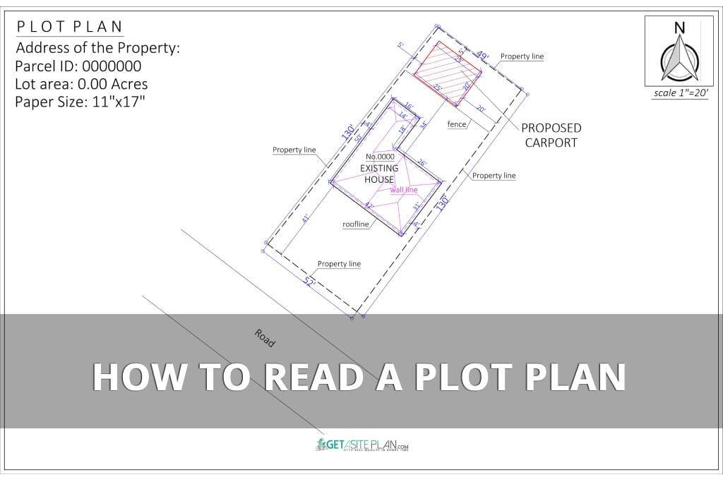

If you’ve ever looked at a plot plan and felt overwhelmed by its symbols, numbers, abbreviations, coordinates, and measurements, you’re not alone.
Understanding a plot plan can be challenging without the right guidance. However, with a structured approach, you will be able to interpret one with confidence by the end of this article.
This one-stop guide breaks down everything you need to know, helping you analyze property boundaries, structures, elevations, and setbacks like a pro.
Let’s dive in.
A plot plan contains numerous elements, symbols, and numerical data, making it difficult to decipher if you’re unfamiliar with construction or land planning.
While it shares many similarities with a site plan, a plot plan is generally simpler to read.
Learning how to interpret plot plan details is a valuable skill, enabling you to actively participate in your project and ensure that the outcome aligns with your vision.

Since plot plans may seem complex at first, here’s a breakdown of each key element to help you easily navigate them.
The most common symbols and elements that appear in a plot plan are:
If you’re familiar with site plans, many of these elements overlap. This similarity can lead to the assumption that reading a site plan is the same as reading a plot plan.
However, site plans often include additional details, such as a vicinity map or impervious surface calculations, which are not standard components of a plot plan.
Nevertheless, let’s break down each of these key elements and their significance in a plot plan.

These details are essential for legal documentation and permit applications. The title block includes project details, ensuring accuracy in records. Having this information clearly outlined helps confirm ownership and zoning compliance.

The scale provides a measurement ratio, allowing for an accurate representation of the property’s dimensions. A north arrow shows land orientation, ensuring the correct placement of elements relative to the surroundings.
This section helps users interpret distances, directions, and the proportional layout of the property effectively. Proper scaling ensures all features are positioned correctly on the plan.

A plan outlines property boundaries, ensuring the owner knows the exact limits of their land (learning how to find property lines is a helpful skill for this aspect). Easements define utility rights, indicating areas where utility companies or other entities have access.
Setbacks ensure zoning compliance, showing the minimum distances required between structures and property lines. These elements are crucial for maintaining legal and functional land use.

A plot plan depicts structures and utilities, differentiating between what is currently on the property and what is planned for construction. Scaled dimensions for real-world use ensure that buildings, sheds, or other structures are correctly positioned.
This section helps confirm that new developments comply with zoning laws and do not encroach on restricted areas. If you’re interested in learning how to draw a plot plan, understanding these elements is essential.

This section identifies driveways, roads, and designated access points leading to and from the property. Properly marked access points are critical for ensuring compliance with traffic and zoning regulations.
The layout provides detailed annotations and a legend to clarify all elements. Ensuring clear and safe access is a fundamental part of property planning.

This section displays the location of wells, septic tanks, and drainage systems, which are crucial for properties without municipal water and sewer connections. Compliance with zoning laws and easements ensures these features are placed legally and functionally.
Proper drainage planning prevents water pooling and soil erosion. Understanding these components helps in maintaining property sustainability.

Contour lines indicate elevation changes, providing insight into how the land rises or falls. Therefore, some plot plans contain these elements, others don’t. Nevertheless, contour line information is critical for drainage, landscaping, and structural stability.
Integrating elevation and slope information ensures proper foundation and water runoff planning.
After reviewing these aspects, you can take a look at different plot plan examples to determine if they now appear clearer to you.
Now, let’s proceed to decipher abbreviations, as they can also bring confusion to some.
Plot plans often contain abbreviations representing various elements, measurements, and zoning requirements. Understanding these abbreviations ensures accurate interpretation and prevents misreading critical details.
Here are some common ones:
These abbreviations are official, and they’re all listed in the U.S. Department of Veterans Affairs guide [1].
While understanding these abbreviations is crucial, misinterpreting other key details on a plot plan can also result in costly errors.

Misunderstanding key elements, such as measurements, setbacks, and utility placements, is a common mistake, particularly when dealing with residential plot plans.
Since these mistakes can lead to legal issues or construction errors, let’s explore how to avoid them and examine your plot plan with clarity and precision.
A common error is misinterpreting the scale or failing to compare dimensions correctly. The drawing should be oriented properly, ensuring a consistent representation of distances.
Misreading annotated values or failing to check the marker points may cause misalignment in construction. To prevent mistakes, always cross-reference the document with real-world measurements and verify the precision of each detail.
Easements and setbacks are critical for legal compliance, yet they are often missed or misunderstood. These features are usually represented by dashed lines or shaded areas, indicating restrictions on land use.
Failing to identify these elements can result in violating zoning laws. Observing the boundary description and ensuring it aligns with property rights is essential for avoiding costly corrections.
Utilities such as water, gas, and electrical lines must be correctly located and understood. Utility placement errors may lead to disruptions or hazards. Many utility lines are depicted with descriptive symbols that need careful interpretation.
It’s essential to examine the plan’s annotation and compare it with on-site markers to ensure proper alignment. Always check the plot plan for topography and access details to avoid construction conflicts.


Understanding a plot plan empowers you to take control of your project, ensuring everything aligns with your vision and helps prevent unexpected setbacks.
An inaccurate or poorly prepared plan can lead to unnecessary expenses or even legal penalties, particularly if it comes from an unreliable source.
If deciphering a plot plan still feels overwhelming, consider getting one from a trusted service like GetASitePlan, where professionals provide an affordable, detail-oriented plan that meets regulations and your requirements.
References:

Whether you’re building on a rural lot or replacing a failing system, septic tank installation is one of the most regulated, and most consequential projects a homeowner can take on.
Ever tried explaining your dream deck without a drawing? Suddenly everyone’s imagining a different patio. That’s where a deck plan saves the day – the visual roadmap that turns “I

A landscape rendering gives you a 3D preview of your garden or yard – a chance to see every angle before any work begins. And it has gone digital. What